TDI-Brooks provides full arrays of hull-mounted and towed sensor acquisition systems to perform hydrographic and marine geophysical surveys around the world safely, effectively, and economically. TDI-Brooks has the global experience, knowledge and resources needed for any marine site survey investigation.
TDI-Brooks employs an experienced team which includes hydrographers, geophysicists, geologists, oceanographers, mariners, cartographers, and GIS and CADD specialists to produce surveys and deliverables of the highest quality.
Areas of Expertise include the following:
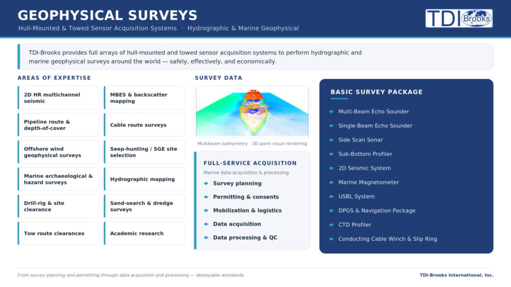
- 2DHR Seismic multi-channel surveys
- Cable Route Surveys
- Marine archeological & hazard surveys
- Burial assessments
- Hydrographic mapping
- UXO surveys
- Tow route clearances
- Bureau of Ocean Energy Management (BOEM) surveys
- Platform and pipeline damage assessments and inspection
- Academic research
- Pipeline route surveys
Download the Marine Geophysical flyer HERE
Marine geophysical surveys are critical to any site investigation and/or seabed mapping project. Marine geophysical survey is the science of measurement and description of features which affect maritime navigation, marine construction, dredging, offshore oil exploration/offshore oil drilling and related activities. For hydrographic surveys a strong emphasis is placed on soundings, shorelines, tides, currents, seabed and submerged obstructions that relate to the previously mentioned activities.
Each TDI-Brooks vessel uses an array of specialized tools to conduct marine geophysical surveys. Along with TDI-Brooks pre-mobilized vessels, we offer portable tool kits which can be shipped to any vessel of opportunity.
TDI-Brooks has conducted a number of high-profile marine geophysical surveys (hazard, hydrographic, shallow 2-D seismic, etc). A marine geophysical survey involves a number of data requirements including water depths, seabed topography, seabed and sub-seabed obstructions, seabed soils, shallow geology and ground conditions and identification of any man-made and naturally occurring hazards that may adversely impact the objective of the site investigation (geohazards).
The basic survey package consists of:
- Side Scan Sonar
- Conducting cable winch and slip ring
- Marine Magnetometer
- Sub-Bottom Profiler
- USBL system
- DGPS System and navigation package
- Single-Beam Echo Sounder
- CTD Profiler
- MRU
- Multibeam Echo Sounder
- 2D Seismic System
Contact us with any questions: info@tdi-bi.com