Seabed Geochemical Seep Hunting SURVEYS
The TDI-Brooks team features experts in conducting offshore Seabed Geochemical “Seep Hunting” Exploration and Heatflow programs for the world’s leading petroleum producers. TDI-Brooks and our partners have been involved for 40 years in the design and execution of numerous global ‘seep hunting’ MBES programs. Geochemical Seep hunting campaigns reduce offshore exploration risk and cost.
TDI-Brooks uses a sequence of specific procedures that we developed and improved over several decades. Our method consistently yields highly accurate identification and a quantitative evaluation of potential sites with migrated oil. Preparation for your project begins with a thorough assessment of legacy seismic and other available geological data.
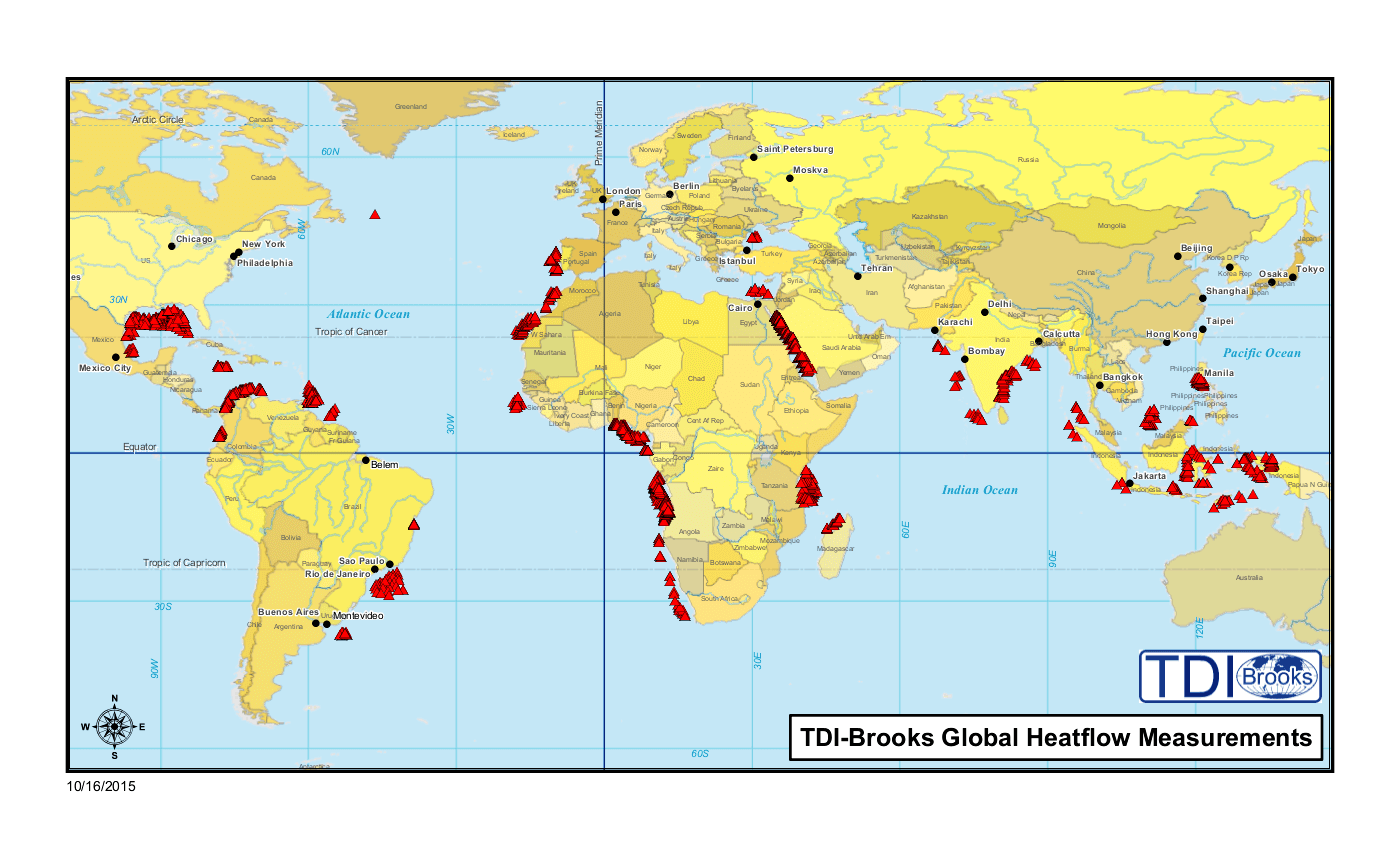
Since 1996, TDI-Brooks has collected over 50,000 deep water piston core sediment samples and heatflow stations for every major oil company, in areas such as the Caribbean, the Gulf of Mexico (USA and Mexico), the Mediterranean, the North Atlantic, and offshore Brazil and West Africa.
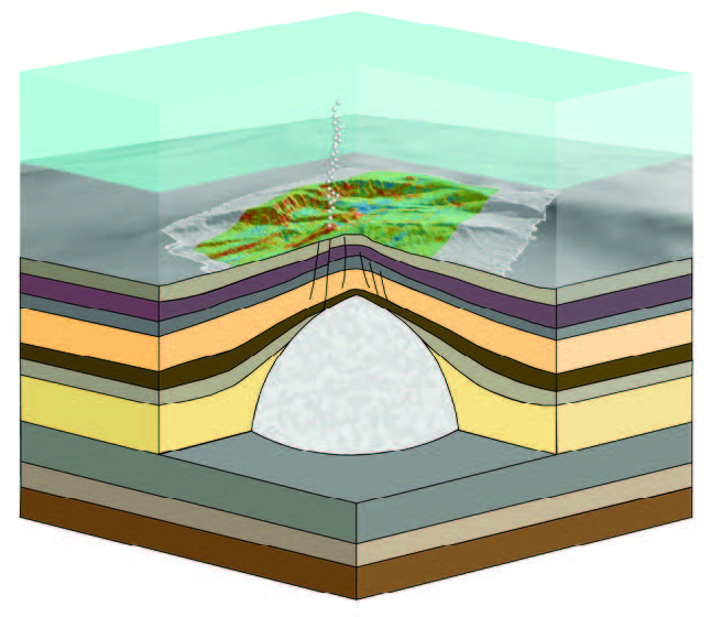
Deep seismic and multibeam surveys are used to select piston coring locations based on surface expression of deep faults and other features related to conduits for upward migration of hydrocarbons.
SGE MBES Global Coverage – 224,350 square kilometers
| 8,000 km2 | 2010 RIL ‘Borojo’ North / South Colombia SGE/HF program | ~8,000 km2, collected with EM710 | R/V GeoExplorer |
| 3,350 km2 | 2011 ExxonMobil Vietnam Blocks 156-159 SGE/HF program | ~3,350 km2, collected with pole mounted Reson 8160 | R/V Rylan T |
| 5,000 km2 | 2015 Tullow Jamaica SGE/HF | ~5,000 km2, collected with EM710 | R/V GeoExplorer |
| 10,000 km2 | 2017 Kosmos Morocco SGE/HF | ~10,000 km2, collected with EM710 | R/V GeoExplorer |
| 115,000 km2 | 2018 TGS MSGBC West Africa SGE-HF program | ~115,000 km2, collected with EM302 | R/V Gyre |
| 83,000 km2 | 2019 TGS Nigeria Seep Program | ~83,000 km2, collected with EM302 | R/V Gyre |
Our interpretation of survey results is made even more robust by comparison with our world-wide database of SGE survey results from 100,000+ samples we have collected, analyzed, and interpreted over the years. We add our knowledge of historical background levels of the analytes for an area, environmental factors, and any unique characteristics of the region being sampled. The process consists of the following sequential steps: review of in-house data, Core Site Selection, Core Acquisition, Laboratory Analysis, and Interpretation.
Deep seismic and multibeam surveys are used to select piston coring locations based on surface expression of deep faults and other features related to conduits for upward migration of hydrocarbons.
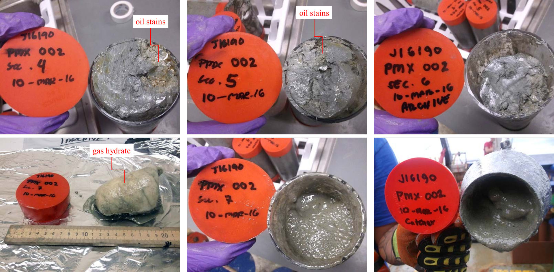
Geochem oily cores and gas hydrates collected
Download the Surface Geochemical Seep Hunting flyer HERE
Surface Geochemical Exploration is a petroleum prospecting tool based on the premise that traces of upward migrated petroleum from deep source rocks and reservoirs can be detected in selected seabed sediments and used to evaluate exploration potential.
Geochemical Posters
- Characterization and source identification of gas bubbles observed at Mississippi Canyon Block 20 (MC20) in the Gulf of Mexico, Michael Gaskins, Dr. Bernie Bernard, Dr. James Brooks, J18324 NOAA MC20 GOMOSES Poster Rev0
- Models of Natural Gas Origin – A Short History, Dr. Bernie Bernard, Bernard Hedberg Poster
Multibeam Core Site Selection
Historically the design of SGE programs has relied on the use of regional 2D and 3D seismic data for the identification of potential surface seepage targets for core sample acquisition. While this technique has produced good results, seismic data has a number of drawbacks:
- High cost and operational complexity of acquisition;
- Limited areal coverage of the area of interest;
- Low resolution.
In the past decade, there has been an increased use of multibeam bathymetric survey data (bathymetry, backscatter and water column plume) as a cost effective alternative / complimentary tool for the identification of seepage targets for SGE core sampling. Compared to 2D or 3D seismic, multibeam surveys have a number of advantages including:
- Lower cost and operational complexity of acquisition;
- 100% areal coverage of the area of interest;
- Very high resolution;
- Low probability of negative impact on marine mammals, environmental permitting issues reduced;
- Rapid turnaround time of data processing and interp / seep target selection;
- Can be used independently or in conjunction with 2D or 3D seismic data for seep target selection;
- Seeps can have a bathymetric or backscatter signature on the seafloor or water column, or both.
TDI-Brooks and our partners have been involved in the design and execution of numerous ‘seep hunting’ MBES programs. TDI-Brooks operates two vessels with Kongsberg MBES systems, the R/V Gyre and R/V Proteus, and has chartered third party vessels equipped with similar MBES systems suitable for seep hunting missions.
Multibeam echo sounders, like other sonar systems, emit sound waves in the shape of a fan from directly beneath a ship’s hull. These systems measure and record the time it takes for the acoustic signal to travel from the transmitter (transducer) to the seafloor (or object) and back to the receiver. In this way, multibeam sonars produce a “swath” of soundings (i.e., depths) for broad coverage of a survey area. Survey speed is typically higher than seismic operations (up to 10 kts).
The area of coverage on the seafloor (swath) per ping depends on the depth of the water, seafloor composition, and the operating frequency of the multibeam sonar. Echosounders that transmit low frequency sound can travel a longer distance in the water (increased range and coverage) but have a lower resolution and are less precise. Sound from high-frequency echosounders cannot travel long distances in water but achieve a higher resolution and are more precise.
Most mid- to deep-water MBES systems are capable of meeting the resolution / data quality requirements for seep hunting missions. In general, lower frequency MBES systems will allow for increased coverage and reduce survey time, but this may be offset by higher vessel costs, as these system typically require a larger vessel to mount the transducer arrays than higher frequency systems (which use smaller transducer arrays).
Hydrocarbon Seep Identification with MBES data
The typical multibeam dataset for seep identification will consist of:
- Bathymetric surface grid (5 – 20m resolution)
- Quantitative backscatter grid (3 – 5m resolution)
- Water column plume data
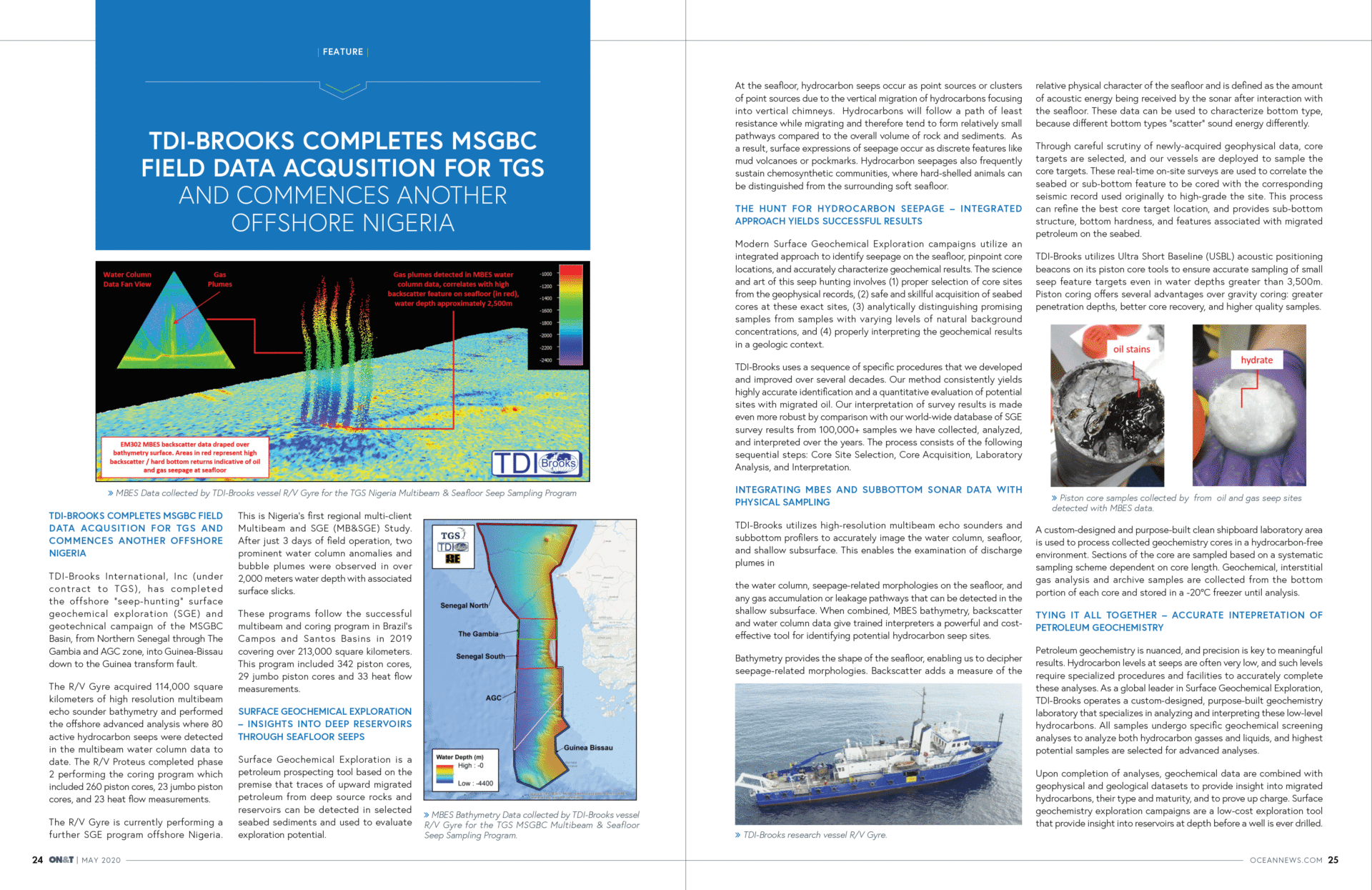
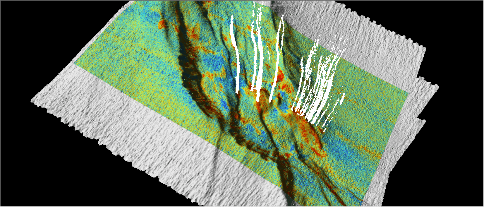
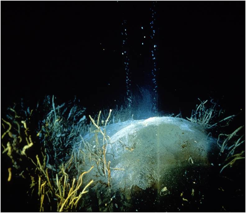
Hydrocarbon seeps occur as point sources or clusters of point sources due to the vertical migration of hydrocarbons focusing into vertical chimneys. Hydrocarbons will follow a path of least resistance while migrating and therefore tend to form relatively small pathways compared to the overall volume of rock and sediments. As a result, surface expressions of seepage occur as discrete features, often with bathymetric character, such as a mud volcano or pockmark.
Backscatter, also collected with MBES, is defined as the amount of acoustic energy being received by the sonar after interaction with the seafloor. This data can be used to characterize bottom type, because different bottom types “scatter” sound energy differently. For example, a softer or smoother bottom such as mud will return a weaker signal than a harder or rougher bottom, like rock.
While some surface seeps have an easily identifiable surface expression, there are many more occurrences with either very subdued or absent bathymetric response. Hydrocarbon seepage provides nutrients to chemosynthetic fauna, and also leads to precipitates such as authigenic carbonate, and, in appropriate temperature and pressure conditions, seafloor or near-seafloor gas hydrate. All of these conditions have an impact on the acoustic properties of the seafloor or the shallow sub-surface and can be identified by an elevated backscatter response. This backscatter response is the reason seep hunting works so well in the marine environment.
In addition to recording the bottom return data (in the form of bathymetry and backscatter), many modern generation MBES systems can record the returns throughout the entire water column. These data can be used to detect bubbles or gas plumes above the seafloor, which could be indicative of hydrocarbon seepage. These plume data can be digitized and georeferenced to correlate with bathymetry and backscatter data.
When combined, MBES bathymetry, backscatter and water column data give trained interpreters a powerful and cost effective tool for identifying potential hydrocarbon seep sites.
Piston Core Acquisition
Our vessels deployed to sample the core targets typically collect additional acoustic data with a hull-mounted sub-bottom profiler prior to core acquisition. These real-time on-site surveys are used to correlate the seabed or sub-bottom feature to be cored with the corresponding seismic record used originally to high-grade the site. This process can refine the best core target location, and provides sub-bottom structure, bottom hardness, and features associated with migrated petroleum on the seabed.
We use USBL navigated piston coring to collect the precisely located sediment core samples. Piston coring offers several advantages over gravity coring: greater penetration depths, better core recovery, and higher quality samples.
Using piston coring to sample depths up to 6 meters significantly reduces intracore variability due to bioturbation, loss by diffusion of gases, and mixing of natural hydrocarbon seepage or pollution in the top meter of sea floor sediments with deeper sections of the core. In particular, the quality of information gained from measurement of sediment gases increases dramatically in sections collected deeper than about 2.5 meters. Sediment gas concentrations can change several orders of magnitude through the 2 to 5 meter depth range in marine sediments, greatly enhancing the type and quality of measurements that can be made on the samples.
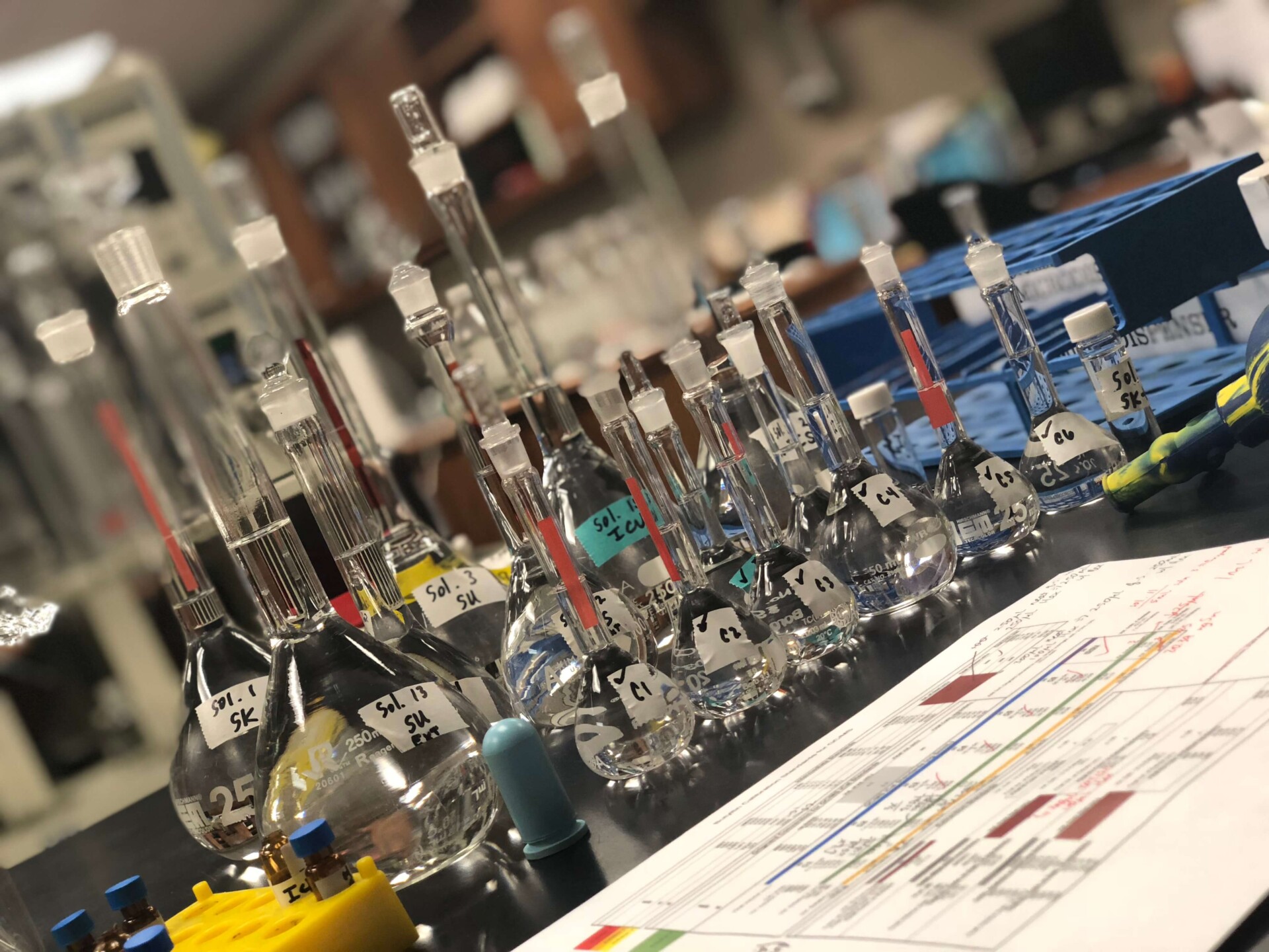
A custom designed and built clean shipboard laboratory area is used to process collected geochemistry cores in a hydrocarbon-free environment. Sections of the core are sampled based on a systematic sampling scheme dependent on core length. Geochemical, interstitial gas analysis and archive samples are collected from the bottom portion of each core and stored in a -20°C freezer until analysis in our Texas laboratory.
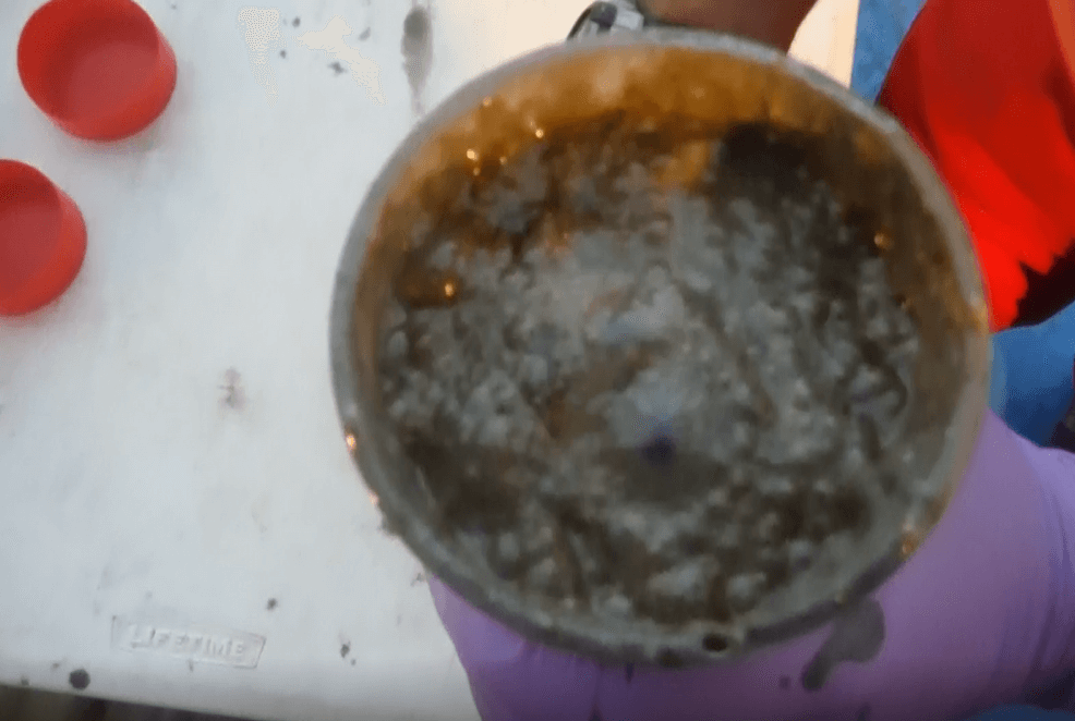
HEAVILY OIL STAINED PISTON CORE SAMPLE, OUT GASSING DUE TO PRESENCE OF GAS HYDRATES
CLICK BELOW & PLAY
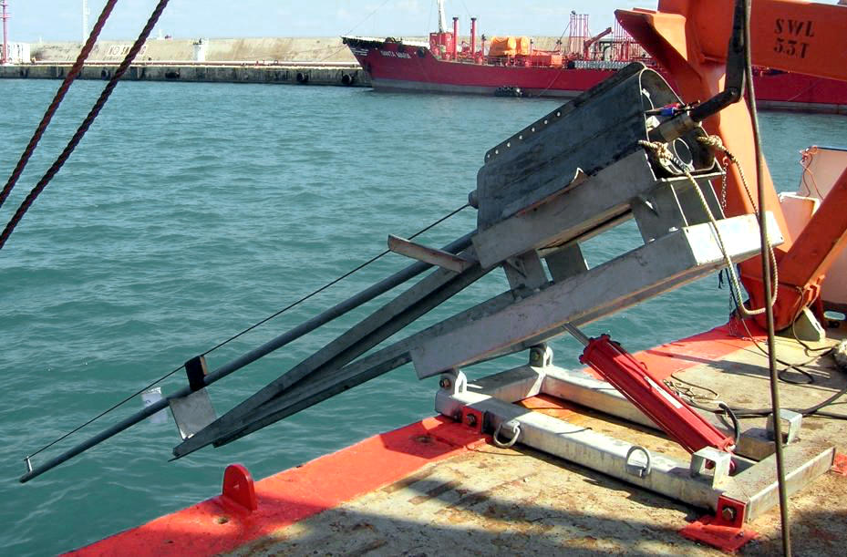
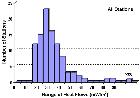
Heat Flow Exploration
Laboratory Analysis
Total Scanning Fluorescence (TSF), C15+-hydrocarbon Gas Chromatographic analysis (C15+GC), and Interstitial Gas analysis (IG) are typically performed on each of the three core sections to evaluate them for the presence of migrated mature hydrocarbons. TSF provides information about petroleum-related aromatic hydrocarbons contained in sediment extracts. C15+GC analysis quantifies petroleum-related normal alkanes (n-C15 to n-C34), isoprenoids (pristane and phytane), and the unresolved complex mixture (UCM) generally associated with sediment extracts that contain oil.
The determination of interstitial light hydrocarbon gases (including methane, ethene, ethane, propene, propane, iso-butane, n-butane, neo-pentane, iso-pentane, and n-pentane) from canned sediment samples is useful because low molecular weight hydrocarbon gases are the most mobile phase of petroleum and, if present in the core section, are easily detected, quantified, and distinguished from local background.
Samples that contain elevated concentrations of migrated petroleum based on the TSF, C15+GC, and/or gas screening data can be further analyzed for saturate and aromatic biological markers and stable carbon isotopes. These more detailed analyses can usually confirm the presence of migrated petroleum and are often used to match hydrocarbons in the sediment extract with a specific produced oil and/or source rock.
Geochemical Interpretation
Abstract
Gas hydrates were recovered from eight sites on the Louisiana slope of the Gulf of Mexico. The gas hydrate discoveries ranged in water depths from 530 to 2400 m occurring as small to medium sized (0.5–50 mm) nodules, interspersed layers (1–10 mm thick) or as solid masses (> 150 mm thick). The hydrates have gas:fluid ratios as high as 170:1 at STP, C1/(C2 + C3) ratios ranging from 1.9 to > 1000 and δ13C ratios from −43 to −71‰. Thermogenic gas hydrates are associated with oil-stained cores containing up to 7% extractable oil exhibiting moderate to severe biodegradation. Biogenic gas hydrates are also associated with elevated bitumen levels (10–700 ppm). All gas hydrate associated cores contain high percentages (up to 65%) of authigenic, isotopically light carbonate. The hydrate-containing cores are associated with seismic “wipeout” zones indicative of gassy sediments. Collapsed structures, diapiric crests, or deep faults on the flanks of diapirs appear to be the sites of the shallow hydrates.
Abstract
Concentrations of the C1-C3 hydrocarbons and stable carbon isotope compositions of methane in recent sediments and seep gases of the Texas-Louisiana shelf-slope region were determined. These gases have been produced by both microbial and themocatalytic processes. Microbially-produced gases consist almost exclusively of methane, having C1/(C2+C3) hydrocarbon ratios greater than 1000 and δ13CPDB values of methane more negative than -60‰. Petroleum-related hydrocarbon gases generally have C1/(C2+C3) ratios smaller than 50 and isotopic ratios more positive than -50‰. A geochemical model based on these two parameters is used to show that natural gas compositions can be altered due to mixing of gases from the two sources as well as by microbial action and migration through sediments.
Light hydrocarbons in the upper few meters of Gulf of Mexico sediments are almost entirely of…
Abstract
Interstitial methane profiles from six sediment cores taken on the slope and abyssal plain of the Gulf of Mexico can be explained by simple kinetic modeling. Methane is apparently produced at a constant rate and microbially consumed in the sulfate-reducing zone. Rates of production and consumption are estimated from best-fit solutions to a steady-state diagenetic equation. Production and consumption balance to form uniform concentrations of 5 to 10 µll-1 in the first few meters of slope and abyssal sediments. Effects of upward diffusion from large accumulations of methane in sulfate-free zones deeper than about 10m are not detectable.
Geochemical Laboratory Analysis
We take great pride in providing the highest quality trace-level geochemical analyses that go above and beyond the capabilities and scope of typical regulatory methods offered by other laboratories. Our methods are based on highly modified EPA methods that are performance-based and have been historically proven in numerous domestic and international programs over the past two decades. Our experienced geochemists review the data to ensure that they are scientifically sound and exceed our customer’s requirements and requests.
GEOCHEMICAL LABORATORY INFO HERE